


LAKE SAINT ANNA
Lake Saint Anna – Tinovul Mohoş Natural Reservation is situated in the southern part of Harghita County, north of the Bodoc Mountains, south of the Harghita Mountains.
Lake St. Anne – Tinovul Mohoş Natural Reservation (ROSCI0248) is a special natural conservation area (SCI), part of the coherent European ecological network Natura 2000, a network that protects biodiversity by preserving the natural habitats of community importance, wildlife and species of plants and contribute to maintaining and restoring their favorable status.
The area of Lake St. Anna – Mohoş Peat-Bog is 400 hectares and is located in the commune of Cozmeni. In the south, it borders with the Ciomad – Balvanyos natural reservation. The area is the property of the commonage of Lăzarea, which has gradually recognized the value of the existing treasures and is paying more and more attention to their protection.
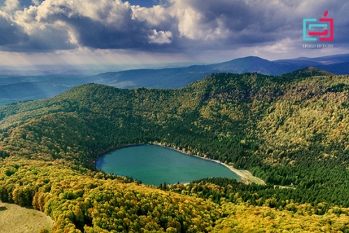
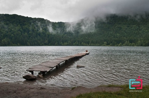
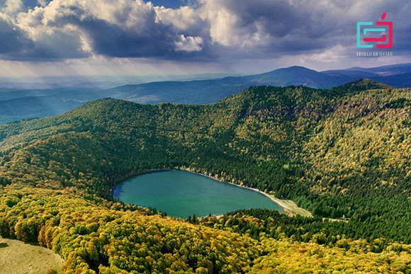
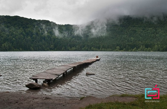
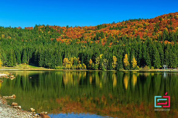
Lake Saint Anna is one of the most attractive natural sights in Szeklerland. The lake was formed at the bottom of the only remaining volcanic crater in Central and Eastern Europe, in the last, the most southern block of the volcanic line of the Harghita Mountains, in one of the twin craters of Ciomad Mountains (the other crater is filled with Tinovul Mohoş.). It’s water surface is 949-950 meters above sea level, being part of Mohoş Natural Reservation.
The volcanic arch of the Oriental Carpathians – to which the Ciomad Mountains belong – was formed by a strong volcanic activity in the third period of the Earth on the northern and eastern edges of the Transylvanian Basin. Ciomad consists of one large volcanic structure with two craters. The last eruption of the Ciomad volcano, according to the most recent international research, dates back ten thousand seven hundred years ago. Other researchers estimates the last time of volcanic activity as 35.000 years ago. According to Attila Pilbáth and Zoltán Pál, the unpublished results of the latest research shows that a 30.000-year-old sludge sample has been found, so the lake is older.
The history of Lake St. Anna in the last ten thousand years has lived through several phases. Research from previous years has identified several distinct situations: according to a study realised by Zoltán Pál and Attila Pilbáth about Lake St. Ana, now nine thousand and eight hundred years ago, was a shallow lake, predominant with a peat bog status, then about eight thousand and eight hundred years this state was replaced by swollen swamps and marsh lakes.
About seven thousand and fifty years ago, it becames a mesotrophic lake with increasing water levels and up to two thousand seven hundred years ago the lake had a fluctuating level. Later, about seventy years ago, profound oligotrophic states dominated, and the depth of the lake could have exceeded 12 meters. “The first traces of clearly defined anthropogenic deforestation were eroded by approx. 1000-900 years ago – can be read in the study of Zoltán Pál and Attila Pilbáth. – From the 700-year-old border, traces of human activity can be detected continuously, and the anthropogenic eutrophication associated with the fall of water has begun. On the northern shore of the swamps was formed by the floating peat-bog with a low water level. Rapid and sustainable change of the peat-bog’s flora is a clear sign of the human impact on the northern coast of the lake. ”
In contradiction to the regular form, in the form of a funnel of the volcanic lakes, today’s track of wheels of Lake St. Anna, due to the accelerated recharge in huge areas is very low. Also, as a result of recharge, the average depth, maximum depth, the surface and the lake perimeter have decreased.
The shape of the lake is similar to a painting palette. The first reliable data about the lake comes from József Gelei, a professor at the Institute of Geography at the University of Cluj, which in 1909 measured 21.3 hectares. According to the measurements of ninety years later by the students from the Babeş-Bolyai University, Geography Faculty in Cluj-Napoca in 1999 and 2000, the area of Lake St. Anna was 19.3 hectares. The decreasing area may be associated with lower water levels.
The first note about the depth of the lake is related to Balázs Orbán, who in 1867 pushed a 12.5-meter-long log on the ice – because the best measurements can be made on ice – and measured about 12.5 meters, but the lake may have been deeper..
The first professional survey is related to the name of József Gelei, according to which, in 1909, the highest depth was 8.3 meters. Csaba Jánosi from Miercurea-Ciuc elaborated a study in 1971 and measured the maximum depth of 7.2 meters. The next study was carried out by geography students from Babeş-Bolyai University in Cluj-Napoca in 1999 and 2000, when depths of 6.3 and 5.5 meters were determined. (The 5.5 meters of the measurement from 2000 is due, among other things, to the fact that it was a very dry summer.) So, according to experts, the maximum depth now varies between 6-6.3 m. It fluctuates because the water level in the lake can vary by up to 60-70 cm after an immense melting of ice or snow. With ultrasonic instruments, the first map of the thickness of the sludge was finalized in 2000, thanks to Zoltán Pál and his associates. From this can be shown that the sludge layer can exceed even four meters under the deepest parts.
The water of the lake is fed only from rainfall falling on it’s surface and water that infiltrates from the edge of the crater. As a result, in 1909 in it’s composition were fewer dissolved minerals than distilled water, so it’s freezing was easier. The faster freezing of the lake’s water can still be observed today, just like the very thick layer of ice on the lake. According to Zoltán Pál’s measurement in 1999, the average thickness of the ice layer was over 70 cm, but in many places a one meter thicker layer was found.
According to the specialty literature, in the water of the lake can be found water snake (Tropidonotus natrix), steam (Triton montadoni) and frogs, who are visiting the lake only during the reproduction season.
The species of duck (Anas acuta) nesting on the shore prefer the pluvial layer of peat with shrubs. In 1908 and in the 1940s, the American bullhead pout was populated in the lake. Their number has fallen, but they have not disappeared: more and more people are evoking their presence – say the authors of the study mentioned above.
Among the arthropods, there is a large population of water-bugs (Notonecta Glauca, Carixa), many dragonflies (Erytromma najas, Libellula depressa, Leptetrum maculatum), crayfish, worms, and also monocellulars.
Inside the crater the vegetation reversal can also be observed by ordinary people: on the shores of the lake there is mainly spruce, while the upper, eastern and southern slopes are mostly beech forests mixed with hornbeam.
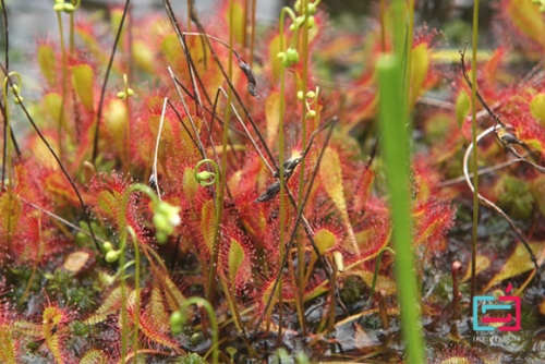
On the north-eastern shore of the lake in the marshes hundreds of years old there are several species of peat-moss, rare species of sedge and sundew with round leaves. At the same time, more than half of the lake’s perimeter is covered with peat moss.
MOHOȘ PEAT-BOG
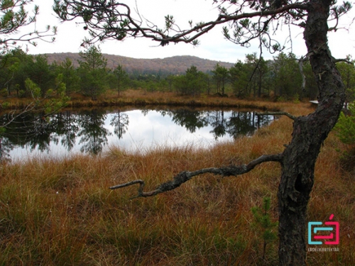
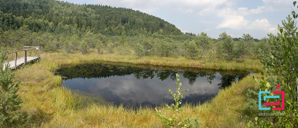
Mohoş peat-bog (known as Kukojzás or Kukujzás-post) is the last, most southern block of the Harghita volcanic line, which fills the northern crater between the two twin craters of Ciomad Mountains. (In the other crater is Lake St. Anna). At 1050 m above sea level, the peat-bog is one of the most valuable botanical protected area in Romania, part of the natural reservation, Mohoş.
According to the latest researches, the Mohoş crater was created from explosive products accumulated at the crater’s edge after a volcanic explosion. The crater’s recharge was facilitated by the faster destruction of the eastern pyroclases and the erosion activity of the Veres stream, which sprang from the crater. The former crater was gradually turned into peat-bog, which was nutrient-poor and cold, chemically acidified (pH 3.8-4.1).
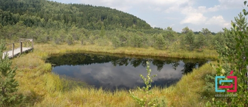
The peat-bog is unique in Europe with ten meters, about 3 million cubic meters thick and its surface of 80 hectares. It is approximately pentagonal, with a maximum longitude of 1000 m and a latitude of 800 m. The water supply of the peat-bog is ensured by the rain falling on it’s surface, therefore the water and humidity supply indicators are highly dependent of season and the amount of fallen rain. Jókai Mór believed that in the middle of the nineteenth century there could be seen two or three hundred small or larger ponds in this place, but he probably overrated this number, it is also true that the number of ponds over the years was much reduced: in 1894, Istvánffy Gyula recorded twenty-nine ponds, and Emil Pop in 1960 only thirteen.
In 1908 the landowner of the composer’s estate in Lăzarea connected the peat-bog with drainage ditches, “so that the giant moor of the peat-bog can be exploited and the cattles that pass in the area not to enter in the marsh.” Subsequent drainage and deforestation resulted in a significant reduction in the content of the peat-bog. According to István Urák and his colleagues, the first official presentation proposing protection of the 240 hectare Mohoş peat-bog was dated on December 18, 1975 and declared as a protected area in December 1980.
Mohoş peat-bog became famous for it’s residual plants from the ice age, although, as recent research has shown, the peat-bog is not interesting and valuable only from the botanical point of view, but also because of the numerous rare arthropod habitat.
In the 1950s, Emil Pop, a biologist and university professor, made a list of all the species of plants and animals existing in the peat-bog and since than, thanks to many researchers, the list has been expanded.
Mohoş can be considered as a mixed forest with peat moss, largely covered by a marshy forest. “The peat – depending on it’s botanical, physical and chemical characteristics – contains peat moss, predominantly mixed moss. Preserve glacial relics, such as the species: Drosera rotundifolia, D. Obovata; Andromeda polifolia; Scheuchzeria palustris; Eriophorum vaginatum or Empetrum nigrum; Vaccinium oxycoccus.
The structure of the marsh species is characterized by a small number of species and a large number of uniqueness. The dominant vegetation is the Sphagnum carpet. It’s main plant associations are: Scheuchzerietum-semly, Andromeda-Neil, Sphagneto-Eriophoretum vaginati or Eriophoreto-Sphagnetum, Pinetum silvestris vacciiniosum, Pinetum-Betuletum caricetosum echinatae, Almatum glutinosae caricetosum elongatae or C. remotae, Piceto -Betuletum, Betuletum vaccinaosum “- we can read in the research of Mr. István Urák, Ferenc Samu, István Máthé, Adalbert Balog: Arachnida: researches in Mohoş Peat-bog.
The study group, between 2003 and 2005, identified a total of 108 species of spider in the peat-bog’s area. These represents 21 families, István Urák and his colleagues identified three new species of spiders for the fauna of Romania (Cnephalocotes obscurus, Maro minutus, Taranucnus setosus) and demonstrated the existence of two species (Zelotes clivicola, Scotina palliardi) and identified the existence of two rare species (Notioscopus sarcinatus, Gnaphosa nigerrima). They have found dominant spider species of the peat-bog is the wolf spider called Pirata hygrophilus, and in the beech forest the spider called Coelotes inermis.
Regular grazing, unregulated tourism and widespread forest harvesting have endangered the specific flora and fauna of the peat-bog.
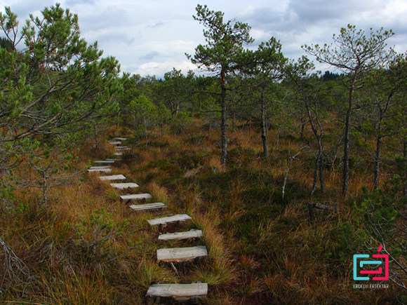
Recognizing this, the Csíki Hiking and Nature Conservation Association (CSTTE) has taken decisive steps to save Mohoş Peta-bog, while in 2000, as a result of a successful project, with the support of the Polgár-Társ Foundation, it was built the first suspended trail of Romania in Mohoș Peat-bog.
According to researchers, the fate of the peat-bog depends today largely on stopping the erosion activity of the Veres stream. Many suggestions have been made to stop the recharge of Lake St. Anna in the hope that, it will be implemented in the near future.
