
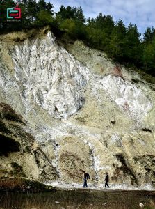

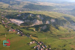
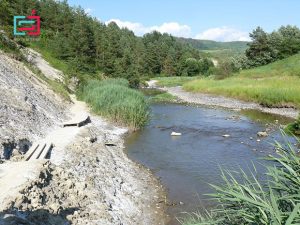
In the eastern part of Transylvania, in Szeklerland, there is a region – the only one – which has got its name for its mineral resources: The Land of Salt. Here is the huge salt table from Praid, part of it being broken by the Corund River, thus creating the unique and special “Salt Canyon”.
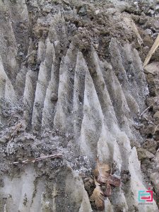
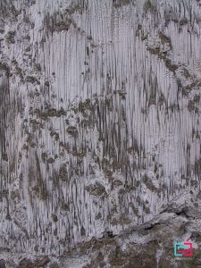
Salt mass that releases significantly from its environment has resulted in specific surface karstic forms. On the surface of the earth’s crust, the karst relief occupies a special place, because of all types of relief, it is the only formation formed exclusively due to the sedimentary rock type. In the perimeter of the salt mountains, salt rocks, we can see the phenomenon of saline carst, on the surface of the salt areas can appear small and large funnels, which resemble the karst phenomenon of limestone areas.
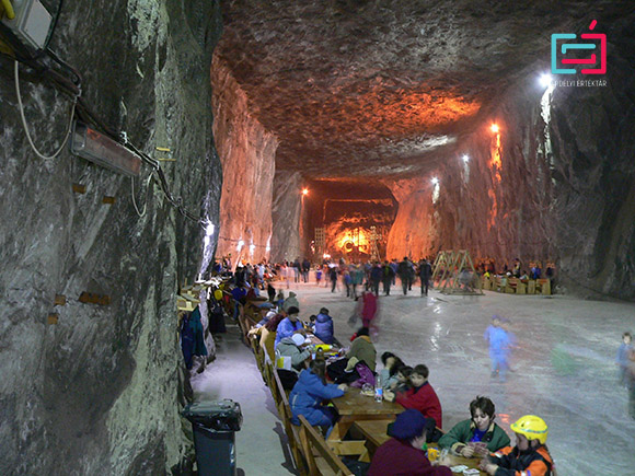
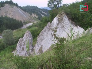
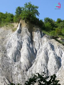
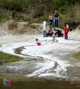
Salt Canyon is located in the southwestern part of Salt Mountain, basically at the defile of Corund stream. In the salt canyon we meet those salt cliffs, which are known as the salt cliffs of Praid and has been a tourist attraction since the end of the 18th century.
Part of the Salt Canyon and the Salt Mountain, 60 hectares have been declared as protected natural geological areas (according to law nr. 5/2000).
On the south-western side of the salt mountain (with other name: Great Lagoon) there is the salt canyon, this being the defile of the Corund stream (Big-water stream), where the brook cut the salt column between the salt mountain and the Gyilkos side (called Gyurkos), thus detaching a small hill (Small Raven).
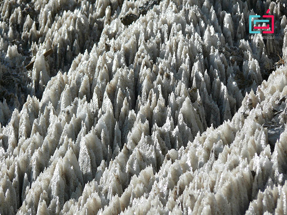
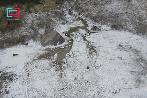
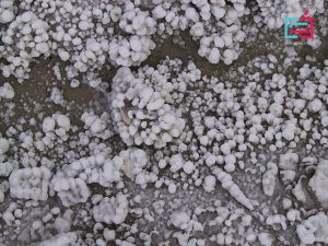
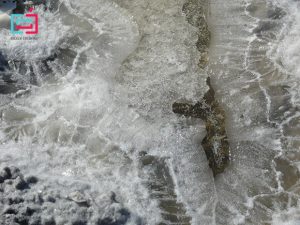
The karst forms of the salt canyon are made up of rock halts, which in rainy weather are gray, and when the weather is beautiful shines in white. Salt fields and eroded remains of the salt rocks are spectacular, salt walls, salt crests with sharp edges, and small salt slopes decorates the salt canyon. At the base of salt rock there are many salt springs, leakage of salt, of which the higher flows go up to Corund stream and the thin layer of salt that precipitates out of their water in dry weather results in white salty deserts. In the salt pits we can see similarly bizarre salt formations, in the collapse generated on the trail of the former Elizabeth accumulation.
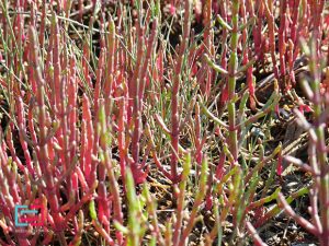
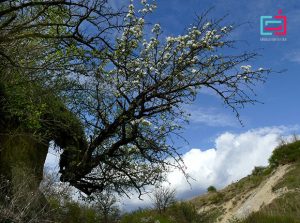
In present, the halophilic plant association around salty springs consists of the following species: Limonium gmelini, Salicornea herbacea, Aster tripolium, Spergularia salina, Salsola soda, Artemisia salina, Plantago maritima și Statice gmelini. The study by Gönczi Lajos (1890) contains valuable data and his collection of plants kept in Odorheiu-Secuiesc, such as Artemisia salina Willd.
The salt canyon’s formation time is difficult to be determined. After Orbán Balázs: “the stream left its course under Haramul-Mare a century ago (roughly around 1760), and turning to east, had dug a beautiful tunnel under the salt mountain.” In Sófalvi András’s opinion, Orbán Balázs may be wrong in the determination of the period, because on the map that was made around 1769 the Corund stream was described as it is today. The map description does not include data, which would indicate that this event would have occurred recently. No material refers to this event (Fichtel, Fridvalszki, Benkő József), so it can be assumed that the formation of the salt canyon happened in earlier historical times.
According to the geologist Bányai János (1941), the Corund stream flowed from Ocna de Jos along the way to the old mine and was poured into Târnava Mică. Later a deeper trench formed due to a series of water channel ruptures, which departed Corund water and, at the same time, drained the lake that covered the meadow between Ocna de Sus and Ocna de Jos. According to other opinions, the previously existing artificial surface mine cavities chain has been washed away by the drenched stream.
The salt canyon in the opinion of Vintilă Mihăilescu and Székely András is epigenetic.
Imagining his formation, the stream flowed on the surface of the salt mountain and deepened the valley epigenetically. More likely, that prior to the formation of the Salt Mountain, the Corund stream was continuously poured into Târnava Mică until the end of the new Pleistocene, when the salt mountain began to rise.
According to Tövissi József’s theory: The Salt Mountain, with its rise, gradually stopped the flow of Corund stream. Behind it a large, swollen lake was formed, being anchored in antecedent by the left arm of the River Târnava Mică between the saddle between Kövesvápa and the Salt Mountain. The beak of the lake was soon loaded with the alluviums of the Corund stream and it’s branches, and finally reached the Salt Mountain. In the same time, the lower flow of the Corund stream with the help of soluble salt has developed a canyon, the pool of the lake filled with a 500 meter plain, resumed the stream from upper Corund. After that, keeping up with the rhythm of movement, the steadily growing salt gradually penetrated the salt and
cut him with a narrow strait, thus creating the antecedent state of the lower stream of the Corund stream.
Zentai Zoltán (1994) measured the accelerated rhythm of karst development on one side of the previously existing Corund stream, more precisely at the Kádas Pit. In his opinion, the history of dolin formation could have been as follows: the stream, deepening the pool, thinned stopping layers of the water, so that a part of the water would have leaked through the bottom of the trench. This is how the first valley was formed, which has expanded and increased, so a large proportion of the water was directed downhill. Meanwhile, on the top of the valley the filing was thinned, and began the formation of a new valley, which then swallowed more and more water until the total amount of water had disappeared in this valley. With this occasion, the first valley has lost its water supply, and its development has entered in a new phase, so they have continually formed recesses in the form of a closed plate without valleys.
Most likely, so it happened in the Salt Canyon, between the cliffs of the salt rock the stream found a new way with the help of valley and formed a valley, later, a correlated system of caves was formed, and after its collapse and partial release, the Salt Canyon would have been created.
Nowadays, besides the geography department of Babeş Bolyai University from Cluj Napoca, the Csolnoky Jenő Foundation takes care of the cleanliness and the touristic operation of the Salt Canyon Reserve.